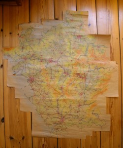
A first hand-drawn sketch of the Republic of Kalm (original scale 1:1,000,000). Tarott, the capital, in the west at the Tarott Bay at the West Sea – by far the biggest city in the country. Other big cities are Herlenz in the south, located in the Juhne River Valley, Pern in the north-east, at the Ahre River, Orlent and Vennburg in the Kelm Valley mining region (Orlent next to the big Kohn Lake) in the middle east of the country and Nerschach, between Tarott and Pern in the Middle Fora Valley. In the north, the Vinn Sea is the natural border of Kalm, the eastern border runs along the Egiten high mountain range, the southern border runs parallel to the Juhne River Plain, the West Sea is the western resp. south-western border. Important secondary mountain ranges are Fennplatt north of the Kelm Valley and Solm between Tarott in the west and the Upper Fora Valley in the middle of the country, where Forberg and Wittersberg are located. The 150km long and 40km wide Kohn Lake in the middle east is the biggest lake in the country, the Krabis lake district lies in the center of a triangle between Nerschach, Pern and the Vinn Sea. The longest north-south extent of the Republic of Kalm is about 1080km, the longest east-west extent approx. 920km.
Urban Variations added
Search
Info
-
Recent Posts
Archives
- September 2018
- June 2018
- May 2018
- March 2018
- February 2018
- January 2017
- December 2016
- April 2016
- February 2016
- January 2016
- December 2015
- May 2015
- October 2014
- August 2014
- June 2014
- December 2013
- October 2013
- September 2013
- August 2013
- June 2013
- May 2013
- April 2013
- March 2013
- February 2013
- January 2013
- November 2012
- April 2012
- March 2012
Categories

